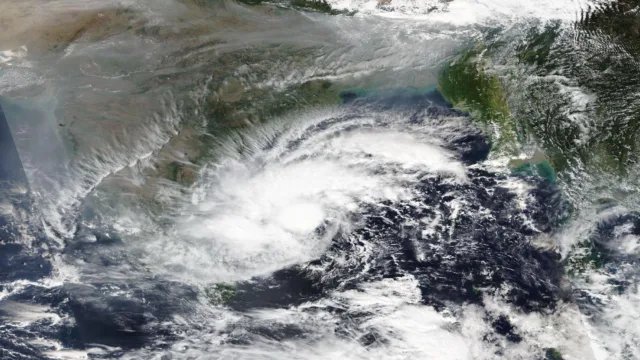
The depression over the Bay of Bengal has slowed down as it moves towards the Andhra Pradesh coast, the India Meteorological Department (IMD) said in its latest bulletin at 9:30 pm on Sunday. The system is still a depression, not yet a cyclone, and is expected to strengthen into Cyclone Akvan by Monday evening.
At 5:30 pm on Sunday, the depression was about 920 km south-southeast of Visakhapatnam and 780 km east-southeast of Chennai, IMD said in National Bulletin No. 4. It was moving north-northwest at about 7 km/h, slower than before, with winds of 45–55 km/h gusting to 65 km/h.
01. When will it become a cyclone?
IMD expects the depression to become a deep depression by Monday morning, a cyclonic storm by Monday evening, and a severe cyclonic storm by Tuesday evening. It may strengthen further into a very severe cyclonic storm by Thursday, November 19, with winds of 120–130 km/h gusting to 145 km/h, while still at sea. The timing is later than IMD’s 3 pm bulletin had suggested, which had put the cyclonic storm at 11:30 am on Monday.
Once the system reaches cyclonic storm strength, it will be named Akvan, a name contributed by Iran. IMD has not yet given a landfall place or time.
02. Pre-cyclone watch and rain warning
IMD has put a pre-cyclone watch on the Andhra Pradesh and south Odisha coasts. Extremely heavy rain of more than 21 cm is likely over north coastal Andhra Pradesh on November 19 and 20, and heavy rain is expected over Tamil Nadu, Puducherry and the Andaman and Nicobar Islands. Fishermen have been advised to stay off the sea from November 18 to 21.
Andhra Pradesh disaster management officials have said the landfall point is not yet fixed because the system is following an unusual track. IMD’s next bulletin is due at 2:30 am on Monday.
What to do: People on the Andhra Pradesh and Odisha coasts should follow IMD bulletins and state disaster management advice, avoid going to sea, and keep emergency supplies ready. This is the third cyclonic storm to form in the Bay of Bengal in about a month.